AirGon
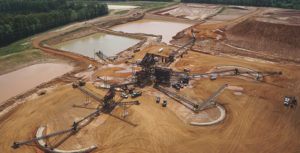
Memphis Stone & Gravel’s drone experience
Drones are revolutionizing the aggregate industry for the better, but understanding the data is essential to the change. Keep Reading

AirGon named North American distributor for YellowScan
AirGon, a subsidiary of GeoCue Group, is now the North American distributor for YellowScan. Keep Reading
AirGon Loki
Loki is AirGon’s third generation Global Navigation Satellite System (GNSS), Post-Process Kinematic (PPK) direct geopositioning system for drones. Keep Reading
AirGon appointed as DJI Enterprise dealer
AirGon LLC has been appointed an official DJI Enterprise dealer, enabling it to offer a range of DJI products. Keep Reading
AirGon BYOD Mapping Kit
AirGon’s Bring Your Own Drone Mapping Kit allows users to collect topographic models, perform volumetric calculations and generate digital orthophotos for planimetric mapping with low cost drones. Keep Reading
AirGon BYOD Mapping Kit
AirGon’s BYOD Mapping Kit provides everything you need to perform local area mapping — minus the drone. Keep Reading
AirGon AV-900 Metric Mapping Kit
The AirGon AV-900 Metric Mapping Kit (AV-900 MMK) is a compete small unmanned aerial mapping kit of software and hardware for small area metric mapping projects such as volumetric analysis and high resolution, high precision topographic mapping. The AV-900 MMK… Keep Reading
View from above: Obtaining volumetric data
Using a drone and low-cost camera, producers can make accurate volumetric computations. Volumetric data is a critical piece of information for aggregate operations. Yet economical, accurate and timely collection of such data remains elusive for most operators. Several major developments… Keep Reading
AirGon to host drone-collected volumetrics workshop
AirGon is set to host a two-day drone collected volumetrics workshop June 11-12 in Toronto, Canada at the Hilton Garden Inn, Toronto/Ajax. The event will include a comprehensive overview of using a small UAS to collect and process data for… Keep Reading