Author
Legal requirements for drone use
Starting your own drone program isn’t a daunting project, but aggregate producers should familiarize themselves with the requirements before deploying a drone. Keep Reading

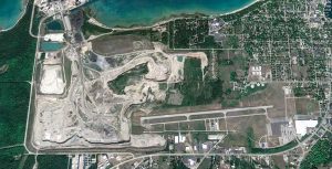
View from above: Obtaining volumetric data
Using a drone and low-cost camera, producers can make accurate volumetric computations. Volumetric data is a critical piece of information for aggregate operations. Yet economical, accurate and timely collection of such data remains elusive for most operators. Several major developments in technology during the past eight years have enabled a new approach to collecting volumetric data for surface mining and stockpiling. Bearing a digital camera, a small unmanned aerial system (sUAS, or drone) can rapidly collect imagery that can be subsequently processed into a very accurate 3D model of the imaged area. From this sUAS-collected model, volumetric information can be computed, along with ancillary data such as image maps of the collected area. This new technique provides, at a substantially lower cost, faster and more accurate information than do traditional techniques. Even better, these new drone-based collection methods are amenable to owner-operator deployment models, enabling mine owners a new level of control over the volumetrics management process. In this overview article, we will introduce a bit of the technology behind… Keep Reading